

C-RTK3 X20P Centimeter-Level Positioning Module
The C-RTK3 X20P is an integrated positioning module that combines professional-grade positioning, industrial-grade attitude awareness, and multi-layer security protection. Built on the u-blox X20 full-band GNSS platform, it supports all-constellation, all-band concurrent reception, delivering centimeter-level positioning accuracy through RTK/PPP-RTK technology. Powered by the STM32H523 high-performance processor and integrated with the RM3100 industrial-grade electronic compass, it features a built-in spectrum analyzer for real-time RF interference monitoring, Galileo OSNMA navigation message authentication, and secure boot. With CAN FD bus support, it can operate as both an RTK rover and base station. Meeting the demands of harsh industrial environments and compact device integration, it provides highly reliable, plug-and-play precision positioning services for high-end applications including unmanned systems, intelligent driving, agricultural machinery navigation, industrial automation, and robotics.
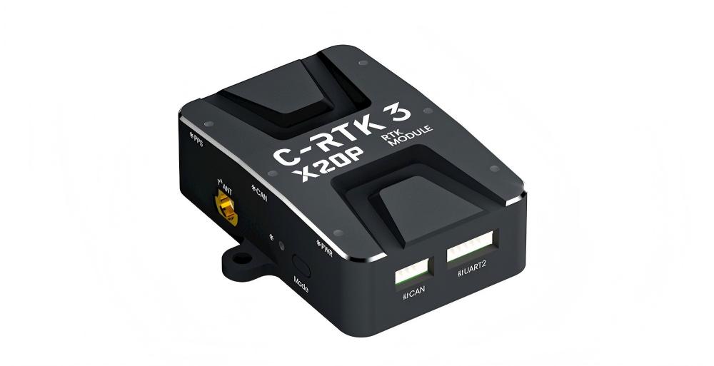
Product Features
- Full-band GNSS positioning (GPS / GLONASS / BeiDou / Galileo / QZSS / NavIC)
- PPP-RTK (PointPerfect) precision point positioning support
- 672 hardware channels with 25 Hz high refresh rate
- STM32H523 high-performance processor (280 MHz)
- Dual-mode: RTK rover and base station capable
- Galileo OSNMA navigation message authentication (anti-spoofing)
- Built-in CW interference detection and spectrum analysis
- Secure boot, configuration lock, and tamper-proof storage
- MIL-STD-810G vibration resistance (7.7g RMS)
Electrical & Hardware Specifications
| C-RTK3 X20P | Specifications |
|---|---|
| Built-in Processor | STM32H5 (280MHz, Flash 512KB, RAM 128KB) |
| Hardware Channels | 672 |
| Supported Constellations & Frequency Bands | GPS: L1C/A / L2C / L5 GLONASS: L1OF / L2OF BeiDou: B1I / B1C / B2a / B3I Galileo: E1-B / C / E5a / E6 QZSS: L1C/A / L1C/B / L2C / L5 NavIC: L1 - SPS / L5 - SPS |
| Assisted & Augmented Positioning | AssistNow™ Live Orbits: GPS L1C/A, Galileo E1, QZSS L1C/A, BeiDou B1I SBAS: EGNOS / GAGAN / MSAS / WAAS / BDSBAS u-blox PointPerfect correction service (Flex / Live / Global) |
| Security | Built-in CW interference detection & spectrum analysis; Galileo OSNMA navigation message authentication; Secure boot (signed firmware only), configuration lock, tamper-proof storage; Active antenna short/open detection |
| Positioning Accuracy | Single Point: Horizontal 1.2 m, Vertical 2.0 m DGNSS Aided: Horizontal 0.6 m, Vertical 1.0 m PPP-RTK: Horizontal < 6 cm, Vertical < 10 cm RTK: Horizontal 1 cm + 1 ppm, Vertical 1 cm + 1 ppm |
| Max Update Rate | 25 Hz |
| Convergence Time | PPP-RTK: < 40 s RTK: < 7 s |
| Startup Time | Cold Start: 25 s Hot Start: 2 s Aided Start: 2 s |
| Sensitivity | Tracking: -167 dBm Cold Start: -148 dBm Re-acquisition: -160 dBm Hot Start: -158 dBm |
| PPS Time Pulse | Pulse Accuracy RMS: 20 ns Pulse 99% Confidence: 60 ns Frequency: 1PPS (default), configurable 0.25 Hz ~ 10 MHz |
| Built-in Electronic Compass | RM3100 |
| Measurement Range | ±1100 μT (wide dynamic magnetic field adaptation) |
| Resolution | 13 nT @200 Cycle Count; detection sensitivity 2.7 nT @1 Hz |
| Noise Level | 15 nT @200 Cycle Count; noise floor 4 pT/√Hz (1Hz) |
| Linearity | 0.50% within ±200 μT |
| Communication Protocols | CAN: DroneCAN / CAN FD UART: NMEA 4.11/4.10/4.0, UBX, RTCM 3.4, SPARTN 2.0.2 |
| Communication Baud Rate | 1 Mbit/s (CAN) 8 Mbit/s (CAN FD) |
| Firmware Upgrade | Supported |
| Default Firmware | C-RTK3 M4C |
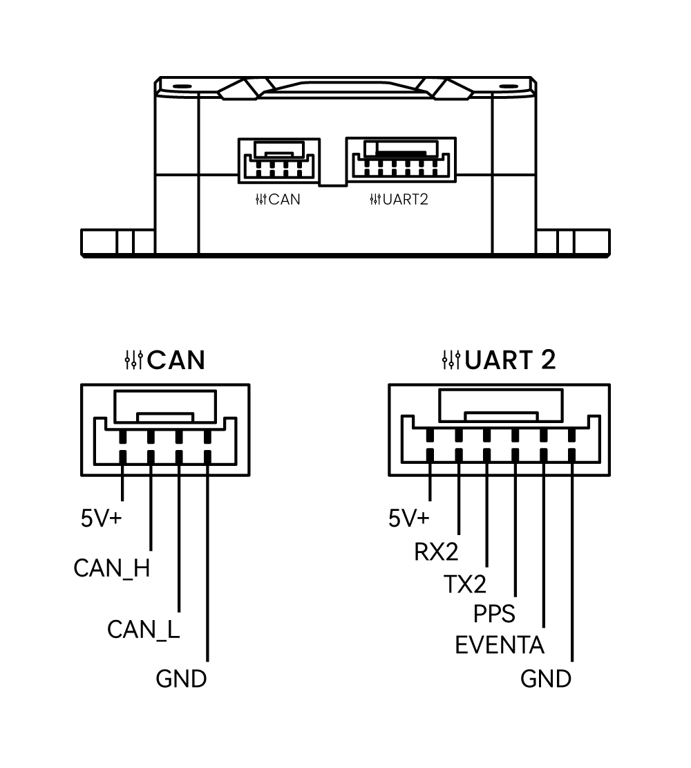
| Data Interfaces | 1 × UART (JST GH 1.25 4P) 1 × CAN (JST GH 1.25 4P) 1 × USB Type-C 1 × ANT (BWMCX-KEF) |
| Operating Voltage | 4.75 ~ 5.3V (200 mA) |
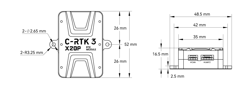
| Dimensions | 52 × 48.5 × 16.5 mm (Including mounting holes) |
| Weight | 30 g (Excluding antenna and cable) |
| Operating Temperature | -15 ~ +85 ℃ |
Dimensions
C-RTK3 X20P Dimension Drawing
LED Status Indicators
NOTE
The silkscreen markings are located beside the LED indicators; the RTK status LED is inactive in base station mode.
| Silkscreen | Icon | Blink Pattern | Description |
|---|---|---|---|
| PWR |  | Solid on | Power input normal; the module is powered |
| SYS |  | Slow blink | Blinks once per second; the system is running normally |
| SYS |  | Fast blink | Firmware writing / upgrade in progress |
| SYS |  | Solid on | Solid on indicates a module fault; troubleshooting is required |
| PPS | | Solid on | No position fix yet; no PPS output |
| PPS | | Slow blink | Blinks once per second by default, synchronized with the PPS pulse |
| CAN |  | Fast blink | CAN link established; data communication is normal |
| Mode |  | Slow blink | Working mode: normal rover |
| Mode |  | Solid on | Working mode: normal base station |
| RTK |  | Off | Not in RTK mode; the indicator stays off |
| RTK |  | Solid on | RTK fixed solution obtained (inactive on the base station) |
Purchase
Pin Definition
C‑RTK3 X20P System Parameters
NOTE
The following are internal configuration parameters for the C‑RTK3 X20P; modification is generally unnecessary.
| Parameter | Range / Options | Default | Description |
|---|---|---|---|
CAN1_BITRATE | 1000000/500000 | 1000000 | Standard CAN (without CAN FD) bus bitrate; must match flight controller CAN_P1_BITRATE |
CAN1_FD_BITRATE | 1–8 (Mbps) | 4 | CAN1 FD data bitrate; must match flight controller CAN_P1_FDBITRATE |
CAN1_FD_EN_MODE | 0~2 | 2 | CAN FD mode: 0=disable; 1=force enable; 2=auto |
CAN_NODE_ID | 0~127 | 0 | CAN node ID; 0=auto-assign; set unique non-zero value if conflicts occur |
CAN_R | True/False | False | CAN 120Ω termination resistor; True=enable |
FLASH_BOOTLOADER | True/False | False | Update bootloader; auto resets to False after completion |
GNSS_BASE_ECEFX | -2147483648.00 to 2147483647.00 | — | Base ECEF X coordinate in cm (GNSS_BASE_MODE set to 1) |
GNSS_BASE_ECEFY | -2147483648.00 to 2147483647.00 | — | Base ECEF Y coordinate in cm (GNSS_BASE_MODE set to 1) |
GNSS_BASE_ECEFZ | -2147483648.00 to 2147483647.00 | — | Base ECEF Z coordinate in cm (GNSS_BASE_MODE set to 1) |
GNSS_BASE_H_CM | -2147483648.00 to 2147483647.00 | — | Base height WGS-84 HAE in cm (GNSS_BASE_MODE set to 2) |
GNSS_BASE_LAT | -90.000 to 90.000 | — | Base latitude in decimal degrees (GNSS_BASE_MODE set to 2) |
GNSS_BASE_LON | -180.000~180.000 | — | Base longitude in decimal degrees (GNSS_BASE_MODE set to 2) |
GNSS_BASE_MODE | 0~2 | 0 | Base position mode: 0=Survey-in; 1=Fixed ECEF; 2=Fixed LLH |
GNSS_BASE_PACC | 0–4294967295 | 1 | Fixed base position accuracy in 0.1mm |
GNSS_CFG_MODE | 0/1 | 1 | Receiver config: 0=bypass; 1=auto by controller |
GNSS_DYN_MODEL | 0~13 | 10 | Dynamic model: 0=Base;1=Quasi-static;2=Robot; 3=Pedestrian;4=Automotive;5=Motorcycle;6=Racing;7=Heavy Machinery; 8=Marine;9=Air(<1g);10=Air(<2g);11=Air(<4g);12=Wearable;13=Unconstrained |
GNSS_ITFM_SEND | True/False | False | Send interference/spoofing detection data via CAN Fix2 message |
GNSS_MODE | 0–65535 (bitmask) | 239 | Satellite systems: Bit0=GPS, Bit1=SBAS, Bit2=Galileo, Bit3=BeiDou, Bit4=IMES, Bit5=QZSS, Bit6=GLONASS, Bit7=NavIC |
GNSS_PPP_ENABLE | 0/1 | 0 | Enable/disable PPP quick configuration; 1=enable, recommended off in mainland China |
GNSS_RATE_MS | 25–500 (ms) | 200 | GNSS output period (200ms=5Hz; 40ms=25Hz max) |
GNSS_RTK_MSM_VER | 0–255 (bitmask) | 16 | RTCM MSM version: Bit4=MSM4, Bit7=MSM7; base station only |
GNSS_SVIN_ACC_M | 0~5 | 3 | Survey-in min accuracy in m (default 3m) |
GNSS_SVIN_DUR_S | 0–4294967295 | 30 | Survey-in min duration in seconds |
GNSS_UART2_BAUD | 9600–8000000 | 230400 | UART2 baud rate |
GNSS_UART2_PROT | 0–65535 (bitmask) | 1 | UART2 output protocol: Bit0=UBX, Bit1=NMEA, Bit2=RTCM3X |
GNSS_USB_PROT | 0–65535 (bitmask) | 5 | USB output protocol; same bit definitions as GNSS_UART2_PROT |
GPS_MB_ONLY_PORT | 0/1 | 0 | Dedicated UART2 for MovingBase; 1=enable, data not forwarded to CAN |
GPS_TYPE | 0~18 | 2 | Role mode: 0=Standalone; 1=RTK Base; 2=RTK Rover; 17=MovingBase Base; 18=MovingBase Rover |
MAG_CAN_SEND | 0/1 | 1 | Enable/disable compass data; 1=enable, 0=disable |
UBX_PPS_DUTY | 1–99 (%) | 10 | PPS duty cycle |
UBX_PPS_POL | 0/1 | 0 | PPS polarity: 0=idle low, rising edge; 1=idle high, falling edge |
UBX_PPS_PRD_US | 0–50000000 (μs) | 1000000 | PPS pulse period in μs (0=Off) |